All We Need Is…Radiocarbon: Geolocated Radiocarbon Dates from Ireland

Radiocarbon Map01

(Image: Robert M Chapple)

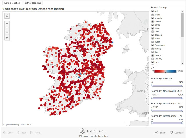
For those who may not be aware, I wish to draw your attention to a hugely impressive and important new resource from Robert M Chapple. Not content with his wonderful Catalogue of Radiocarbon Determinations & Dendrochronology Dates, Robert has just released Geolocated Radiocarbon Dates from Ireland – a sleek visualization interface which displays Irish radiocarbon dates on an interactive map of Ireland.

With this fantastic tool, it is now possible to search, select, exclude, define, zoom down, separate and review details of 8288 radiocarbon and 313 dendro dates from Ireland within a geographical framework. Yes, you heard correctly. 8288. 313. Such data carries great potential for anyone interested in Irish archaeology – from professionals and researchers to students and interested members of the public – enabling both a macro and micro (radiocarbon) snapshot of the island. And its ongoing.

As a brief example, I was just playing around with it a few minutes ago and I zoomed down to an area for which I would have presumed to be fairly familiar with known archaeological information. There I found a ref to an old burial, something I had certainly read about years ago, but which had only recently come back with a C14 date. The horizon? Right slap bang in the middle of a period I’m most interested in. Score.

You can access the new Geolocated Radiocarbon Dates from Ireland Dataviewer on Roberts blog in embedded form, along with a detailed introduction to the tools and interface (which I highly recommend reading first).

Or you can view it in stand alone form on the tableau public server.

My congratulations and deep deep thanks to Robert and his many helpers and partners in crime who helped produce this fantastic new resource. I have a feeling it will fast become a staple for professionals, post graduates and researchers alike, among many others. Radio, what’s new? Go use it. Rinse. Repeat.

OMG: Ogam in 3D – Exciting New Database from Dublin Institute for Advanced Studies

102107426_b3cd240e84

Ogham, Aghadoe, County Kerry.
Image: Jeremy Keith/Flickr Commons
(Used under a CC Licence)

A long-awaited and very exciting resource: the new online database ‘Ogham in 3D’ from Dublin Institute for Advanced Studies is coming shortly. Its already online with a small selection (50+) of individual stones. The site is going to offer 3D scans of Irish Ogham stones, alongside their associated historical, etymological and archaeological data; ‘bringing all of the available information together in a single searchable archive’.

In other words, a GOLDMINE for researchers. Really. You have no idea how disparate a lot of this information has previously been.

Ogham stones are crucial to understanding the development of Early Irish Christianity. Not only are the inscriptions the earliest recorded efforts at replicating the aural sounds of primitive Irish; but as formulaic monumental inscriptions involving named ancestral figures, they are quite possibly the earliest archaeological evidence for Insular Irish Christianity itself. Continue reading

Knitting An Early Medieval Scottish ScARF

A Scotty Scarf!

Image: Jose M Vazquez (Flickr Commons)
Used under a CC Licence

If you are a scholar of Early Medieval Ireland, you are also a scholar of Early Medieval Scotland. We can’t begin to understand one, without viewing it in conjunction with the other. It’s that simple.

Ok, there’s also Early Medieval Britain, Wales, Norse Scandinavia, Merovingian & Carolingian Europe; but Early Medieval Scotland is really, really important. It occupied a central position between Ireland, Northumbria, Saxon & Norse Britain and onwards to Scandinavia. If the Irish and North Sea can be considered major medieval ‘highways’; then Scotland was possibly one of the biggest and most complicated medieval ‘cultural roundabouts’ of its day. Continue reading